|
|
|
Day 56: 10 September 2008 |
Guildford to Dorking |
Map Next Top |
 |
|
 |
St. Mary's church, Guildford |
 |
|
 |
|
 |
|
 |
|
 |
|
 |
|
 |
|
 |
|
 |
|
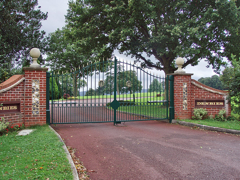 |
The upper entrance to Denbies vineyard |
 |
|
 |
|
 |
|
 |
|
Day 57: 11 September 2008 |
Dorking to Merstham |
Map Next Top |
 |
|
 |
|
 |
|
 |
|
 |
|
 |
|
|
|
|
|
|
|
|
|
|
|
Day 58: 12 December 2008 |
Merstham to Knockholt Pound |
Map Next Top |
 |
|
 |
Footbridge across the M23 |
 |
|
 |
|
 |
|
 |
|
 |
|
 |
|
 |
|
 |
|
Day 59: 13 December 2008 |
Knockholt Pound to Wrotham |
Map Next Top |
 |
|
 |
Skirting Star Hill Wood on the sodden downs |
 |
|
 |
|
 |
|
 |
|
 |
|
 |
|
 |
|
Day 60: 22 March 2009 |
Wrotham to Burham |
Map Next Top |
 |
|
 |
|
 |
|
 |
|
 |
|
 |
|
 |
|
 |
|
 |
|
 |
|
 |
|
 |
|
 |
|
 |
|
 |
|
 |
|
 |
|
 |
|
 |
|
 |
|
 |
|
 |
|
 |
|
 |
|
 |
|
 |
|
 |
|
 |
|
 |
|
Day 61: 16 April 2009 |
Burham to Lenham |
Map Next Top |
 |
Blue Bell Hill; the restart |
As we were visiting Gatwick Airport on the way to Toulouse (for a boat trip along the Canal du Midi), I included in the plan a spare day so that I could take in another stage of the E2. The idea was to have a fairly gentle day of 12-14 miles, but some extensive planning revealed that a 17-mile day would leave me much better placed for a final push to Dover, pencilled in for July.
So after a very pleasant stay at the Hartsfield Manor hotel (just north of the airport), we took the hire car to Blue Bell Hill and Chrissy dropped me off at 10 a.m. while she visited Maidstone.
 |
The Robin Hood, Blue Bell Hill. Note the new sign! |
Unfortunately, the spring weather wasn't cooperating, and although the drive to Blue Bell Hill had been dry heavy rain was falling as I set off. I noticed that the characteristic pub sign had been updated, but spent the next few minutes sorting out wet weather gear.
 |
|
An easy stretch along the minor road led back the way we'd just driven, to a memorial to the Air Ambulance helicopter crew who died in a nearby crash in 1998.
Then a steep and slippery downhill section led to the busy A229 dual carriageway. Luckily, the Way only joins this for a few yards, then leads down through lovely woodland to flatter ground. A gap in the hedge caught my eye, as it gave access to the amazing Neolithic site of "Kit's Coty House", the remnants of a long barrow dating from 4300-3000 BC.
 |
|
Crossing the A229 in civilised fashion by a good footbridge, the Way also crosses the new Channel Tunnel Rail Link again here, before climbing back up to the top of the Downs.
 |
|
This was a bit of a haul, but the rain had eased off so it wasn't unpleasant.
 |
|
The path seemed to follow the edge of fields on top of the escarpment, but a NDW sign pointed into the woods and down. After a bit of doubt, an ancient track carved into the hillside in thick woodland looked to be the way and I followed it until I'd lost about 150 feet in altitude. The track seemed to be more and more unlikely, and with no NDW markers to give me faith in the route I finally scrambled precariously up a very steep mud bank and hacked through the brambles until I reached the field edge again. I decided that following this was better than the officially-signed route, only to spot a NDW marker confirming that I was back on the correct path. So I'm not sure what the earlier sign was supposed to indicate!
 |
|
 |
|
Approaching Detling, the Way takes a flinty lane to the A249 (another busy dual carrigeway). A huge footbridge takes the path across the road, but as the access ramp looked about half a mile long I elected to take the short route across the road and was in the village a couple of minutes later.
I'd omitted to bring any supplies, not even a bottle of water, so I took a diversion and stocked up at the nice little Post Office.
 |
|
In any case, the Way itself takes a route through the village (contrary to the OS Map which shows a route further north), before striking north and up an energy-sapping ascent onto pleasant open Downs.
 |
|
The next section was probably the most scenic along the NDW so far, with rolling hills and great views. Although there are still some woodland sections they are not too deep and there are plenty of more open parts.
 |
|
 |
|
Another descent brought me to Hollingbourne at about 2.45.
 |
|
 |
|
As the weather had warmed up rather, and the threat of rain had receded, the low-lying and reasonably flat straight to Lenham looked an attractive prospect, even though I was feeling a bit tired from all the travelling.
 |
|
This sculpture provided some amusement, and a little reward for extending the walk past this point and into Lenham.
 |
|
A row of cottages marked the turning-off point. I'd arranged to meet with Chrissy at the cemetery in Lenham (it looked the most likely spot to have space to park), so I kept along the road as it turned south to the village.
 |
|
We headed back to Gatwick, stopping off for a bit of tourism on the way.
Day 62: 15 July 2009 |
Lenham to Wye |
Map Next Top |
 |
|
 |
|
 |
|
 |
|
 |
|
 |
|
 |
|
 |
|
 |
|
 |
|
 |
|
 |
|
 |
|
 |
|
 |
|
 |
|
 |
|
 |
|
 |
|
 |
|
 |
|
Day 63: 16 July 2009 |
Wye to Folkestone |
Map Next Top |
 |
|
 |
|
 |
|
 |
|
 |
|
 |
|
 |
|
 |
|
 |
|
 |
|
 |
|
 |
|
 |
|
 |
|
 |
|
Day 64: 17 July 2009 |
Folkestone to Dover |
Map Next Top |
 |
|
The Ship Inn had done us a favour by not being able to provide a full breakfast. Today was going to be busy, with a very long drive across to the Dorset/Devon border then a party at River Cottage HQ in the evening. So realistically, it would be nice to finish the walk before 10 a.m. That would give us time to drive west without too much stress.
So we were away early, and I was actually on the E2 again by 7 a.m. With only 7 miles or so to walk, that should mean a quick getaway from Dover.
 |
|
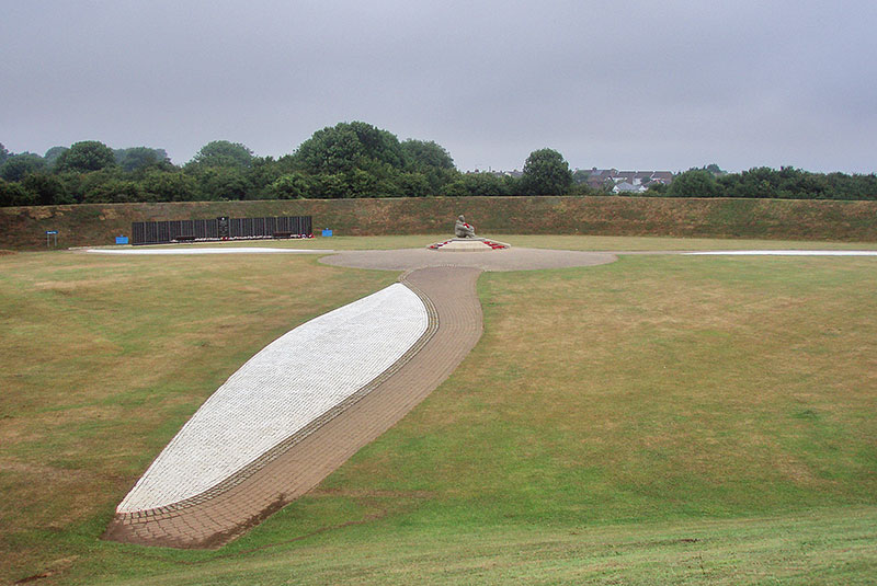
A chilly morning greeted me as I made my way along the top of the cliffs. The long grass was soaking wet, but the path was good as far as the Battle of Britain Memorial. This is more than just a statue or plaque; it's a variety of memorials placed on an atmospheric clifftop site facing the Channel. It was only opened in 1993, the inspiration of a Hurricane pilot, Geoffrey Page.
 |
|
I took my time here as it would have been a shame not to look around the memorial. But then I had to find the start of the descent through a ravine cutting the cliffs at Capel-le-Ferne. Climbing steeply back up, it looked like this was going to be a herd couple of hours.
 |
|
There's clearly a way along the foot of the cliffs, but it seemed very remote from the North Downs Way which keeps to the heights all the way.
 |
|
The first sight of Dover made me realise that this great trek was soon to be at an end. At each rise, the view of container ships and ferries became more and more clear. The Way follows a switchback course along a surprisingly narrow ridge; on the map it appear to be just a cliff edge, but there is steep ground to the left as well as the right as you approach Dover.
 |
|
I was romping along at a pace, only halting for a bit of geocaching along the way. And soon, a couple of descents led to the top of steps leading down to the edge of a beach. Here the path turned inland, through an underpass and into a dull housing estate.
 |
|
Passing the surprisingly-situated ruins of the Knights Templar Church, I was starting to look for the end of the walk. But there was a sting in the tail! A steep path rose up from the road to the loftily-perched Drop Redoubt, providing the last interest on the walk.
 |
|
The superb views across to Dover Castle were well worth the extra climb, but soon I reached some slippery steps leading down into gloomy woodland.
 |
|
 |
|
From here, the way ahead was confusing. No signs, and a busy roundabout. So I followed the GPS route until I finally arrived at the seafront and rendezvous with Chrissy.
 |
|
 |
|
It didn't sink in that that walk was over. It was so far from Portpatrick, and such a long time since I started out, that there was no feeling of achievement or elation.
But over it is. So now I can go for a walk without having to incorporate some of the E2 into the journey, and I can go to other parts of the country without feeling that I've wasted an opportunity to knock off a few more miles from the E2.
However...I've noticed that there is another E route in Britain. The E9 runs from Dover to Plymouth, and rather than give up walking at Dover, I fancy the idea of continuing along the coast. Firstly back west to Folkestone, then along the E9 via the Isle of Wight to Plymouth. Then, how about the South West Coast Path?